
Setouchi 5 “Kaido” Cycling
Not just the Shimanami Kaido!
Yumeshima Kaido, Hamakaze Kaido, Tobishima Kaido?!
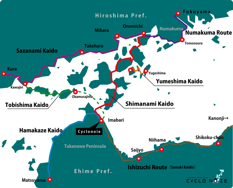
In the Seto Inland Sea, there are numerous picturesque cycling spots and routes, including the renowned “Shimanami Kaido,” which is a sacred place for cyclists. The “Tobishima Kaido” connects to the western side of the Shimanami Kaido and offers stunning scenery, linking seven islands. The “Yumeshima Kaido” is a route that connects four small islands and is conveniently close to the Shimanami Kaido. The route from Imabari to Matsuyama’s Dogo Onsen is called the “Hamakaze Kaido.” Furthermore, the coastal area of Hiroshima Prefecture, connecting the Tobishima Kaido and Shimanami Kaido, is known as the “Sazanami Kaido.” In this way, the Seto Inland Sea features several well-maintained cycling courses. The term “Kaido” in Japanese means “sea road.” Why not leisurely enjoy cycling (bicycle strolling) while experiencing the island life and admiring the scenic beauty of the Seto Inland Sea with its bustling ships and picturesque archipelago?
Please be sure to check each official website for the latest information.
2015/11/6 first released
2026/6/8 last updated
Author: MURAKAMI Masayuki
Cycling in the Seto Inland Sea
Around Imabari City in Ehime Prefecture, where CYCLONOIE is located, there are numerous cycling routes that connect the islands of the Geiyo Archipelago. Among them, the most well-developed is the renowned “Shimanami Kaido,” known as a world-class cycling route. To the east of it, there is the “Yumeshima Kaido,” which connects small islands, while on the west side, the “Tobishima Kaido” has gained attention as a scenic cycling spot in recent years. The “Sazanami Kaido,” which runs from Kure to Onomichi on the Hiroshima Prefecture side, links the Shimanami Kaido and Tobishima Kaido, forming a triangular course known as the “Seto Inland Triangle.”
*”Ishizuchi Route” and “Numakuma Route” are temporary names I’ve given them for convenience.
In addition, in Ehime Prefecture, there is ongoing development of cycling routes across the entire prefecture known as the “Ehime Marugoto Bicycle Path.” Particularly, the coastal route from Imabari to Matsuyama is named the “Hamakaze Kaido,” where blue lines and cycle oases are installed for cyclists’ convenience. The “Ishizuchi Route,” which leads to Kagawa Prefecture, passes through the Shikoku Mountains, including the pilgrimage route of the Sanuki Highway, which is also part of the Shikoku Pilgrimage. It has been established as the northern route of the “Shikoku Circumnavigation Cycling.” Let’s now introduce each of these route details one by one.

5 “Kaido” in the Seto Inland Sea
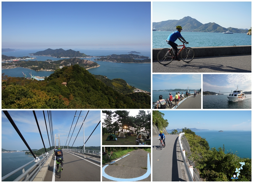
Shimanami Kaido
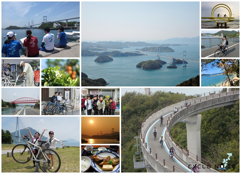
Imabari City ‐ Onomichi City From Imabari, Ehime Prefecture, to Onomichi, Hiroshima Prefecture, the “Shimanami Kaido” is a road that spans the Seto Inland Sea, connecting the islands and linking Shikoku and Honshu. It is designated as one of Japan’s “National Cycle Routes.” Each bridge has a dedicated lane for bicycles and pedestrians. Blue-line markers are installed along the main route and outer loop, and there are well-equipped services for cyclists, such as “Cycle Oases” rest areas where rental bikes can be returned across prefectural borders, facilities for restroom breaks, and “Tousou Rescue” assistance for bicycle troubles like flat tires. These amenities make it a beginner-friendly route, ideal for cycling trips.
For tourists who rent bicycles and traverse the 80 km between Imabari and Onomichi, it is common for first-time sports cyclists to take at least a 2-day, 1-night journey. Besides the main route, there are various course variations, so it’s recommended to plan using maps to check distances and difficulty levels.
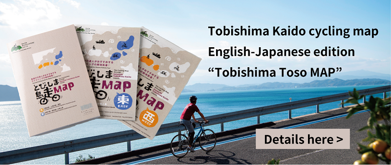
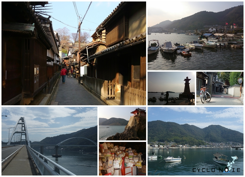
Tobishima Kaido
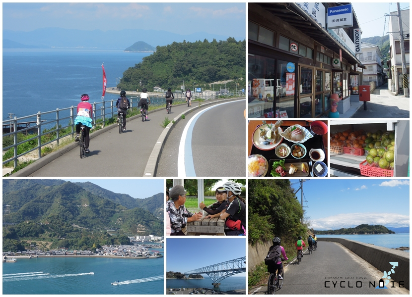
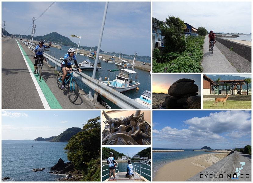
Okamurajima ‐ Kawajiri To the west of the Shimanami Kaido, the “Tobishima Kaido” stretches, connecting seven islands with seven bridges and has been gaining attention from cyclists in recent years. The Tobishima Kaido route from Okamura Island to Akinada Ohashi (Kawajiri, Kure city) entrance is approximately 30 km in the shortest distance. To reach Okamura Island (Imabari city), the starting point of the Tobishima Kaido, one must take a ferry from Imabari Port. Previously considered suitable for intermediate to advanced cyclists, the Tobishima Kaido cycling has become more accessible in recent years. This is due to the improvement of ferry routes that allow bicycle transportation, the emergence of guesthouses, and the launch of comprehensive rental cycle services, making it a route that beginners can now confidently take on. Cycling along the coastline, with relatively low breakwaters, allows cyclists to experience the charm of the Tobishima Kaido while feeling close to the sea. There are also various attractions along the way, such as the historic streets of the Mitarai district, offering a serene landscape to enjoy.
Rental bicycles for the Tobishima Kaido require advance reservations. Some people opt to use the public rental bicycles available on the Shimanami Kaido; however, in this case, the Tobishima Kaido falls outside the service area, and returning the bicycle midway is not permitted. If using Imabari as the base for a round trip, it is essential to pay attention to the ferry schedules.
Hamakaze Kaido
Imabari City – Matsuyama City The coastal route that connects Imabari and Matsuyama, while traversing the Takanawa Peninsula, is known as the “Hamakaze Kaido,” stretching approximately 50 km. It mainly follows National Route 196 and is indeed a pleasant road, as its name suggests, with the refreshing sea breeze. Many cyclists who ride the Shimanami Kaido and stay at CYCLONOIE overnight often embark on this “Hamakaze Kaido” the following day to reach Matsuyama and Dogo Onsen. Along the way, there are plenty of attractions, such as the picturesque cape “Osuminohana,” which offers views of both sunrise and sunset, the wildlife-inhabited “Kashima” known for its wild deer, the famous tile-roofed village “Kikuma,” the granite rock formations of “Cape Shiraishi,” and the renowned filming location of a drama, “Baishinji Station.” It is a route that provides an enjoyable and flat cycling experience.
Please note that there is no service for midway rental bicycle drop-offs on the Hamakaze Kaido. If you rent a bicycle in Imabari or Matsuyama, you will need to return it to the original location. However, depending on the season, there might be a “Cycle Train” service that allows you to carry your bicycle between Imabari Station and Matsuyama Station directly.
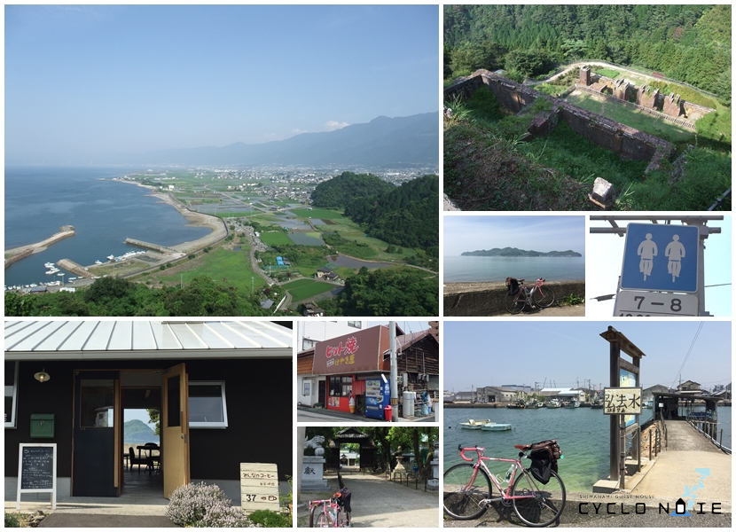
Yumeshima Kaido
Kamijima-Cho, Ehime The “Yumeshima Kaido” is a sea route that connects the islands of Kamijima-cho: Yugeshima, Sashima, Ikinajima, and Iwagijima. The small bridges linking the islands of Kamijima-cho resemble a miniature version of the Shimanami Kaido. You can easily reach the opposite shore visible from ports like Habu Port and Karoto Port on Innoshima with a short ferry trip that takes just a few minutes. The Yumeshima Kaido also features blue-line markers, making travel easy and convenient. After enjoying the vast ocean views from Yugeshima and the pine forests of Hoougahama Beach, you can explore the U-turn course on Sashima or take the one-lap course around Ikinajima. Staying at a guesthouse on Yugeshima or Sashima is also a great way to experience the lifestyle of these small islands. Why not immerse yourself in the local island living experience?
On the islands of the Yumeshima Kaido, there are separate rental bicycle services from the public rental bicycles on the Shimanami Kaido. Each service operates independently and does not allow for cross-island bicycle returns. During your Shimanami Kaido journey, it is recommended to take a detour to the islands of the Yumeshima Kaido or utilize the ferry routes. For detailed information, please refer to map#7 Kamijima-cho in the “Shimanami Toso MAP” .
Sazanami Kaido
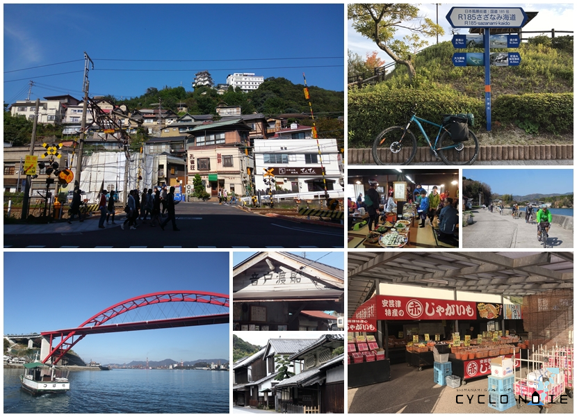
Kure City- Onomichi City The “Sazanami Kaido” consists of National Route 185 and National Route 2, running from Onomichi City to Kure City in Hiroshima Prefecture. This route tends to have relatively higher traffic volume and includes some ups and downs, making it more suitable for experienced cyclists. Nevertheless, I believe that the route linking the historical port town of Kure, the famous Akitsu-town known for its red soil-grown potatoes, Takehara-city often called “Little Kyoto” of Hiroshima, Mihara-city known for its octopus dishes, and Onomichi, a town famous for its sloping streets and its appearance in films, is very appealing. You can enjoy cycling while observing the unique coastal landscape with oyster cultivation rafts and the islands of the Tobishima Kaido offshore.
As there are no separate rental bicycles available for the Sazanami Kaido, if you plan to travel with rental bicycles, you will need to utilize the public rental bicycles on the Shimanami Kaido or the rental bicycles on the Tobishima Kaido. Since these rental bicycles cannot be returned to a different location, it’s essential to plan your return route accordingly. By using ferry routes that connect the islands of the Shimanami Kaido and the Tobishima Kaido, you can create shortcuts or smaller circular routes.
Wider area routes
Ishizuchi Route
Imabari City – Kanonji City The Ishizuchi Route runs along the northern wall of the Shikoku Mountains, which includes the highest peak in western Japan, Mount Ishizuchi, and connects Ehime Prefecture to Kagawa Prefecture along the Hinonada coastline of the Seto Inland Sea. In the city of Saijo-City, there are various places with high-quality natural spring water. The Besshi Copper Mine, once the world’s largest copper mine, is located in Niihama-City. Shikoku-chuo-City is home to one of Japan’s leading paper manufacturing centers. Cycling along this route allows you to experience the richness of Shikoku’s industries. As the route follows the Shikoku Pilgrimage of 88 temples and the Sanuki Kaido, which leads to Konpira-san (Kotohira-gu Shrine) in Kotohira-City, Kagawa Prefecture, you can also enjoy exploring spots with historical significance. Cycle Oases are well-established along this route. Local cyclists often use the so-called backroads that run parallel to National Route 196 and National Route 11 since the main roads have heavy traffic and narrow lanes, making them less suitable for cycling.
On the Ishizuchi Route, you will find road markers called “Blue Lines,” which have the same design as those on the Shimanami Kaido. However, it’s essential to be cautious as these Blue Lines are drawn on loop routes designated as part of the “Ehime Marugoto Bicycle Path,” such as the “Imabari-Saijo Yuyu Rindo” and the “Besshi-Suiha Hana Kaido.” Alternatively, you can follow the “Shikoku Circumference” pictograms painted on the roads or the signs of the Shikoku Pilgrimage to navigate your journey.
Numakuma Route
Onomichi City – Fukuyama City The Numakuma Peninsula, located south of Fukuyama City in Hiroshima Prefecture, is a famous tourist destination known for its nostalgic port town scenery in Tomonoura and its popular cycling routes exploring the islands of Tashima and Yokoshima, crossed by the Naikai Bridge. Along the outer perimeter of the Numakuma Peninsula, you can enjoy the picturesque fishing village scenery typical of the Seto Inland Sea, and there are various spots to visit, including the Abuto-kannon temple. It’s a recommended route for those who want to embark on a peaceful journey, savoring the authentic countryside views unique to Japan.
From Uta Port, Mukaishima on the Shimanami Kaido, there is a ferry service to Tomosaki Port on the Numakuma Peninsula, providing a shortcut to the peninsula from Onomichi City by avoiding the overland route. As the rental bicycles in Fukuyama City are mainly intended for short trips within the city, it is recommended to rent public rental bicycles from the Shimanami Kaido in Onomichi. However, please note that mutual drop-offs between Onomichi and Fukuyama are not possible.